To view PDF files, you must have a copy of the Adobe Acrobat Reader which is available as a free download:
![]()
Manitoba land Initiative
The Manitoba Land Initiative (MLI) is a program to develop, manage and maintain a land information framework necessary to harmonize and share government's geospatial databases, and make them available on the Intranet.
Ultimately, our goal is to provide integrated land information to every desktop in government for planning and operational decision making without having to interact with a GIS specialist or a Data Analyst.
| Rationale: Integrated approach to land management |
| Our Situation |
| The Manitoba Land Initiative Framework |
|
| The business of collecting, storing and displaying geographical information is a rapidly growing information technology segment. In the US, this sector is growing at twice the average growth rate of the US economy (Price Waterhouse benefit study). It is expected that geospatial data will be a key component of the national and global information highways of the 21st century. |
| Studies have shown that for every dollar spent on better land information management, governments and businesses can reap from three to six dollars in benefits within two to four years. These benefits are distributed across a broad spectrum of economic activities ranging from the operation of electricity, gas and water utilities to projects involving agriculture, mining and environmental management. As an ultimate result, government will spend public money more wisely, getting more value for it; it will enable us to make better use of our financial resources, and it can give a significant competitive advantage to Manitoba based industry. |
| Governments around the world have recognized the benefits of an effective framework for land information management. In Canada, the federal government and all provinces excluding Newfoundland and Prince Edward Island are building land information frameworks. Federal and many state governments in the United States, many western European countries, as well as Australia and New Zealand are also developing similar approaches. |
| The trend across jurisdictions is to provide integrated land-related information to decision makers to support cross-government activities such as resource management, sustainable development or encouraging investment in the province. Each of these initiatives has the same basic requirements: |
|
Our Situation |
| The Government of Manitoba has a tremendous investment in Geographic Information Systems (GIS). Building on the experiences of Manitoba Land Related Information System (MLRIS), we recognize the need for a common vision, application of standards and a more integrated approach to land management to ensure more efficient use of land data throughout government. To ensure the most efficient use of our land data we need to systematically manage what we know. In particular, we need geospatial information that correlates human concerns such as land ownership and management, education and health with spatial issues such as property lines, demographics and the distribution of essential services. This means the elimination of departmental boundaries to access land information. Data must flow between departments without constraints. |
| While all participants recognize the long-term benefits to be derived from a GIS, each party is at a different point on the GIS implementation life cycle. The MLI strategy acknowledges these differing positions and permit all parties to participate at their own speed within realistic timeframes. For example, Department of Conservation has already expended significant effort at investigating and implementation standards for data cataloguing and for identification of land parcels. The concern is that others are brought into the group to ensure the standards will work and have value for their needs as well. |
| With respect to technology, GIS hardware and software, standards within the provincial government have not as yet been established, but, approximately 80% of all government GIS installations are or will be configured with the same tools. With most of the technical barriers to integration of data gone, the only remaining barriers would appear institutional. |
|
| The MLI framework includes land data, partners, standards, access systems and protocols to enable timely access to geographic information data in support of policy, decision making and economic development. |
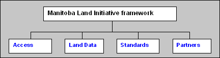
| The proposed Manitoba Land Initiative framework attempts to incorporate the following goals: |
|
Access |
|
Database |
| Some estimates indicate that up to 60% of the total costs of any GIS project are associated with data collection. Therefore, all releasable land data will be treated as a corporate asset with reasonable free exchanges between government departments and agencies. To facilitate this exchange we are creating a catalogue of all land-related data managed by the Provincial Government and its agencies and a central database. |
| Rapid access to data is a primary component of the spatial data infrastructure, as well as the main rationale behind the other thrusts within MLI. Data sharing starts with the MLI Web page containing a list of the common data - Core Maps -- a fundamental dataset that is critical to the objectives of more than one department. It is needed by most users, and therefore, needs to be accessible by all and maintained as the common geospatial referencing system. These most common base maps ensure that all government data is in the same coordinate system and map projection and allows the user to overlay the basemap with other data layers accurately. This core data forms a central database. It is envisioned that this Web site will become a central repository for our corporate land-related "knowledge" containing a list of best practices, a list of departmental projects, and a list of "experts" related to specific areas. |
Technical Architecture |
| Each participating department is responsible for providing and ensuring maintenance and quality control of its own data. Some data will is stored centrally on a shared data server, and some are only available locally, which is determined on a case by case basis. The server's contents and metadata catalogue is managed also by our data providers. This data catalogue will provide metacontent information about available data resources to internal clients. Departments and agencies will be able to access land data or search the land data catalogue through the Intranet by using a simple Web interface to locate the metainformation (who, where, description, purpose, currency). This information infrastructure will enable information to be readily accessed and transported from a variety of decentralized databases for diverse applications. It will permit the controlled electronic exchange of land related information, regardless of location, technology, and managing organization. |
| Once a seamless and online land information environment is created, access to external clients (by adding the browsing and ordering functions) for one-stop shopping for spatial data could be considered. At this point, a whole new range of issues regarding pricing, distribution, licenses, copyright requirements and freedom of information, would need to be addressed. |
| The MLI Database subgroup is mandated to implement the central database. The Office of Information Technology supplied the central hardware and web design requirements. ManWeb, Manitoba's Internet face, is responsible for: |
|
| Managing of online system and network access |
|
Provincial Base Maps |
| Investigation into standardization of base maps has determined that a
singular base map for identification of provincial needs is not possible. Base maps
require different scales and resolutions to facilitate references needs of different
departments and agencies. The Committee adopted the following primary levels of base
mapping:
|
|
Level of base Mapping |
Accuracy |
| 1:20,000 Topographic maps | Less than 1 m |
|
1:50,000 Federal Topographic maps |
less than 10 m |
|
1:500,000 and 1:1,000,000 Provincial base maps |
100m and 200m |
|
Digital cadastral land parcel maps |
+ cm in urban areas |
|
Digital ortho photography-based maps |
2 m |
|
Theoretical quarter section grid system |
derived from digital ortho photography in the south, calculated in the north |
|
Go to top
|
| Throughout government, there are likely over 100 different administrative boundary layers in either or both digital or hard copy formats. Currently, there is no one central source through which these boundaries can be acquired, and in some instances it is also uncertain who is responsible for the maintenance of these layers. Another issue is the fact that these layers very often need to be replicated and adjusted to fit various map scales and resolutions, since one boundary overlay may not fit another due to inherent accuracy variations. Many administrative boundaries are simply described by following section lines or rivers, for example. Other layers are highly accurate and have more precise geographic coordinates, if they have been completed since the advent of GPS surveying. Several established boundaries such as some of the Provincial Parks or Forest Reserves are tied into the section survey fabric but do not necessarily have ground coordinates integrated with them. These issues will continue to be reviewed by the Land Initiative Working Group. |
Metadata Catalogue (Inventory) |
|
|
|
| Paper maps contain metadata, primarily as part of the map legend. In this form, metadata is readily apparent and easily transferred between map producers and map users. When map data is in a digital form, metadata is equally as important, but its development and maintenance often require a more conscious effort on the part of data producers and the chain of subsequent users who may modify the data to suit their particular needs. | |
| Therefore, metadata captures who has been collecting what information, to what standards, and using what procedures. It includes the structure and quality of the data, including important contact information. This information is often referred to as "metadata" and is presented in the form of a catalogue. Functionality is focused on providing enough information for the user to determine if there is data accessible that is relevant to his/her topic, and is it appropriate for his/her needs. | |
| For metadata collection it is necessary to adopt certain metadata standards -- a common set of terms and definitions that describe geospatial data. These standards allow for exchange of collected information about data between different partners (municipal, federal, provincial, international). The Federal Geographic Data Committee (FGDC) in the US adopted a content standard for metadata. In the absence of international standards, this standard has been widely applied throughout the world. Since FGDC is focusing on contributing to the development of international standards ISO TC211 (expected completion in this year), it is very likely that ISO standards will not greatly differ from FGDC. | |
| The MLI metadata subgroup is working on inventory (Data Catalogue) of all land related data managed by the Provincial Government and its agencies. Metalite program has been used as a template for data entry. As well, The International Joint Commission (IJC) has recently completed a metadata catalogue for the Red River Valley in which a considerable amount of Manitoba Conservation's material has been formatted. Data providers (custodian departments) will be responsible for managing and maintaining the metadata about their products. As such, they are the authority on the quality of this information. | |
Land Ownership and Interest (Cadastral) DataIn the land ownership and interest area, there is a need for the development of a comprehensive GIS cadastral layer (identifying location, owners, interests, and value of property) across the several departments involved. Each department should be responsible for maintaining their data within their own layer. As the cadastral layer is the key to integrating much of the existing spatial data, benefit delivery will be constrained until this layer is in place. Without this approach each department would be required to do it alone and incur significant expense at re-developing the same technology and processes. A single view will allow for an easier supply of high quality consistent cadastral information to others, leading to a de-facto standard for spatial data in Manitoba, and opening new revenue opportunities for government. |
|
Business functions related to GISThe Land Information Division of the Department of Conservation has developed cadastral parcel mapping information. Currently they have created and are maintaining parcel maps for approximately 30 incorporated villages, towns, and cities in Manitoba. As these communities include larger centres like Winnipeg, Brandon, Steinbach, and Portage la Prairie it is estimated that they represent 350,000 out of the total 500,000 urban parcels. |
|
| The Land Titles Office within the Department of Consumer and Corporate Affairs is responsible for maintaining ownership information on all titled land in Manitoba. Crown Lands Registry in Conservation is responsible for maintaining ownership and interest information on all provincial Crown land. The Assessment Branch within the Department of Intergovernmental Affairs is responsible for maintaining assessed values for titles property outside the City of Winnipeg. Currently, no ownership or value information is maintained by any of these departments in a Geographical Information System (GIS). The City of Winnipeg is responsible for maintaining assessed values for all their property in the City�s GIS. | |
| The needs of each group vary with respect to data accuracy, timeliness, and degree of integration. Implementation of a comprehensive GIS across these departments to support cadastral data will be more complex than a layer owned by one department. Systems implemented must take into account the multi-participant nature of cadastral data and data maintenance standards must be set for each application. | |
Data conversionAcquisition/development, integration, and maintenance of a comprehensive cadastral layer will likely be one of the most expensive and resource intensive activities involved in the implementation and operation of a GIS. However, cadastral data exists for many communities and areas in Manitoba today. There is a wide range of the accuracy, currency, and completeness of the data that is available. Our implementation strategy includes first cataloguing of the cadastral data that is available today and then identification of an expedient way of consolidating this data for use by all stakeholders. The MLI Cadastral subgroup is working on these tasks. |
|
Benefits and constraintsThere are significant benefits from a coordinated approach to maintenance of cadastral data. Without this approach each department would be required to do it alone and incur significant expense at re-developing the same technology and processes. Having a single view of the cadastral data across government will also promote use among non-government stakeholders and lead to a de-facto standard for spatial data in Manitoba. This consistency will make it easier to supply high quality data to others in a single view and open new revenue opportunities for government. |
|
| However, having cadastral data, that includes owners and interest, available for sharing might result in conflicts with the Land Titles policies and with the Freedom of Information and Protection of Privacy Act (FIPPA), and these issues need to be examined in the next phase. | |
StandardsData StandardsGiven the high degree of inter-connectedness and synchronization required to make shared GIS implementation work, it is critical that standards, guidelines, and procedures be adopted for all aspects of sharing at the business and technical levels. Without solid, workable standards data sharing will result in low quality results. In this regard, MLI adopted general land identification method of all land parcels within the province (PIN - Polygon identification Number). This method will be applied throughout government. |
|
|
|
|
| As well, for a land data catalogue we had to adopt
metadata standards - a common set of terms that describe geospatial data, specifically
who has been collecting what information, to what standards, and using what
procedures.
Go to top As already pointed out technological barriers are not an issue - more than 80% of hardware and software are standardized (ESRI, Oracle). Business needs and sunk investments will require that the proposed strategy acknowledge the need to work in a multi vendor environment. As well, one of our proposed principles is that data sharing processes cannot impact existing processes and projects, but rather build upon them by using the existing processes and projects. |
|