To view PDF files, you must have a copy of the Adobe Acrobat Reader which is available as a free download:
![]()
M - Z
Map Generalization - The process of reducing detail on a map as a consequence of reducing the map scale. The process can be semi-automated for certain kinds of data, such as topographical features, but requires more insight for thematic maps.
Map Scale - The extent of reduction needed to display a representation of the Earth's surface on a map. A statement of a measure on the map and the equivalent measure on the Earth's surface, often expressed as an representative fraction of distance, such as 1:24,000 (one unit in the map equals 24,000 units on the ground).
Metadata - "data about
data" describe the content, quality, condition, and other
characteristics of data.
Metadata is vital in helping potential users to find needed
data and determine whether a data set will meet their needs before they spend the time
and money to obtain and process it. This information will often include some of the
following:
- What it is about
- Where it is to be found
- Who one needs to ask to get it
- How much it costs
- Who can access it
- In what format it is available
- What is the quality of the data for a specified purpose
- What spatial location does it cover and over what time period
- When and where the data were collected and by whom and what purposes the data have been used for, by whom and what related data sets are available, etc.
In the United States, FGDC has developed a standard structure for geospatial metadata, which is the basis for the international (ISO) standard currently being developed.
N
NAD - North American Datum - the official reference
ellipsoid used for the primary geodetic network in North America.
NAD27 - North American Datum 1927. A non-geocentric
horizontal control datum for the U.S., Canada and Mexico defined
by a coordinate and azimuth with origin at Meades Ranch, on the
Clarke 1866 reference ellipsoid. (source -Survey Services 2003)
NAD83 - North American Datum 1983. The
horizontal control datum for Canada, U.S.A., Denmark
(Greenland), Mexico and Central America. Based on the geocentric
reference ellipsoid Geodetic Reference System 1980 (GRS80).
(source -Survey Services 2003)
NAD83(CSRS98) - North American Datum 1983 Canadian
Spatial Reference System. A new realization of NAD83 derived
from an adjustment of the Canadian Base Network and high order
GPS tied to the Canadian Active Control System (CACS). Reference
ellipsoid is GRS80. Depending on accuracy requirements these
coordinates may not be compatible with previous NAD83 values
(June'90, NMIP94). (source -Survey Services 2003)
O
Object - A set of points, lines or polygons in a spatial database that represent a real-world entity. The terms feature and object are often used synonymously.
Orthophotography - The process of aerial photographs that have been rectified to produce an accurate image of the Earth by removing tilt and relief displacements which occurred when the photo was taken.
Overlay (also see layer) - The process of superimposing two or more maps, through registration to a common co-ordinate system, such that the resultant maps contain the data from both maps for selected features. Although the term overlay can be applied to paper based maps, more often it applies to the use of digital data, nevertheless, the principal is the same.
 |
P
Portable Network Graphics (PNG) - A raster data format similar to GIF. It is an open standard developed in response to the restriction of the copyright on the GIF compression.
Q
Query - statement expressing a set of conditions that forms the basis for the retrieval of information from a database. Queries are often written in a standardised language such as SQL.
R
Raster structure - One form of organization for spatial data (whether geographic, photographic, or just graphic). A regular grid of cells covering an area. Each cell can be assigned a single attribute, such as the color to be displayed or the average soil moisture in the area.
Raster files can be quite efficient for representing complex field-like data themes of continuous change, such as a temperature signature or a photographic image. However, for more simple, geometric entities such as roads or text, vector structures usually work better. Printers and monitors are common raster output devices. Raster data formats include GIF, JPEG, and DEM. Adobe Photoshop is an example of raster graphic software. Raster GIS programs include GRASS, IDRISI, Tydac SPANS, and ArcView Spatial Analyst.
Relational Database Management System - RDBMS - A database management system (DBMS) with the ability to access data organized in tabular files that can be related to each other by a common field. An RDBMS has the capability to recombine the data items from different files, providing powerful tools for data usage.
Remote sensing - The use of remote (airborne, space-borne, and sometimes raised platform) equipment to view and study the earth. There are two common products used in GIS: aerial photography and its derivative products - such as digital orthophotoquads - and digital satellite imagery, such as that from Landsat and SPOT.
Resolution - Measures the sharpness of an image.
S
Spatial Analysis - The process of modeling, examining, and interpreting model results. Spatial analysis is the process of extracting or creating new information about a set of geographic features. Spatial analysis is useful for evaluating suitability and capability, for estimating and predicting, and for interpreting and understanding. In GIS there are four traditional types of spatial analysis: spatial overlay and contiguity analysis, surface analysis, linear analysis, and raster analysis.
Spatial Data Transfer Standard (SDTS) - A U.S. Federal Information Processing Standard (FIPS173), which is more than a data format. It is a standard method for defining many new data formats, called profiles. It defines a common set of terminology, appropriate themes, and partial structures. When the acronym is used today to refer to a specific data format (such as in the data sets now distributed by the USGS), it usually refers to the Topological Vector Profile (TVP), the vector data format defined under this standard.
Spatial Modeling - Analytical procedures applied with GIS. There are three categories of spatial modeling functions that can be applied to geographic data within a GIS: geometric models, such as calculating the distance between features, generating buffers, calculating areas and perimeters, and so on; coincidence modeling, such as polygon overlay; and adjacency modeling such as redistricting and allocation.
T
Thematic Map - A map displaying selected kinds of information relating to specific themes, such as soil, land use, population density, suitability for arable crops, and so on. Thematic information may be represented as labeled polygons, lines or points, chloropleth maps, isolines, etc.
Title - A part of the database in a GIS representing a discrete part of the earth's surface. By splitting a study area into titles, considerable savings in access times and improvements in system performance can be achieved.
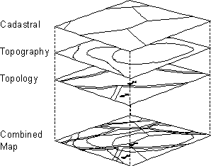
Topography - Shape relationships between connecting or adjacent coverage features.
Topology - The way in which geographical elements are related to each other. The topology of the data must be defined before GIS analysis can be performed.
U
Universal Transverse Mercator (UTM) - An international plane (rectangular) coordinate system developed by the U.S. Army. The UTM divides the world into 60 zones of 6 degrees longitude. Each zone extends 3 degrees east and west from its central meridian and are numbered consecutively west to east from the 180-degree meridian. Transverse Mercator projections may then be applied to each zone.
V
Vector Structure - One of the two major data structures for representing spatial information (such as maps and graphics); the other being raster. The vector structure is efficient for representing object-like entities, such as roads, buildings, text, and geometric shapes. Each entity is stored as a distinct unit, delineated by a series of coordinates, and has one or more attributes attached, usually in a related table.
Although vector structures, such as the one shown in the following illustration, are predominant in GIS, architecture, engineering, and much of graphic design, Web browsers currently do not support them directly. Plug-ins or Java programs are required to view them online. Common vector graphic data formats include CGM, DXF, and PostScript. Adobe Illustrator, Macro-media Freehand, and Corel Draw are examples of vector graphics programs, where ESRI's ARC/INFO, Intergraph's MGE, and MapInfo are popular vector GIS platforms.
W
X
Y
Z